We are

Analyzing past extreme weather in the SoHo Broadway area can give us further insight to new challenges climate change will pose in the neighborhood.
Hurricane of 1821
Despite its inland location, the neighborhood that is now SoHo has had many instances of flooding over the years. One of New York’s earliest recorded tropical cyclones, the Hurricane of 1821, made landfall on September 3 and devastated Lower Manhattan with a 13-foot storm surge. The huge influx of water connected the Hudson and East Rivers all the way up to Canal Street. Observers at the time would have seen the buildings along Canal become waterfront property. Within the current SoHo Broadway district boundaries, basements and low lying areas were flooded. Although the idea of Lower Manhattan becoming completely submerged is horrific, there was potential for the destruction to be even greater. Fortunately, the Hurricane of 1821 hit at low tide and the most severe flooding was concentrated in areas without many residences. Despite massive flooding, few deaths were reported.
Aging Infrastructure Angst
Infrastructure failures can drastically exacerbate natural disasters. In recent memory, although Superstorm Sandy caused much more serious flooding and damage elsewhere, a pump failure at a power station plunged SoHo and much of Lower Manhattan into darkness for days. Even during less-extreme weather events, aging infrastructure can create problems. In SoHo, the area where Grand Street intersects Thompson Street and West Broadway has been plagued by sewer backups and overflows during heavy rains. As reported by amNY in 2004, residents lamented the damage done to restaurant basement kitchens by a sewage backup, and noted that it had been a recurring problem in the area since the 1970s. Changing neighborhood demographics and an increase in residents and restaurants likely compounded the problem caused by aging pipes.
Legacy of Collect Pond
The body of water that came to be called Collect Pond once stretched across parts of what is now Chinatown and had been settled by the Munsee before Europeans arrived. As New York City developed, parts of the pond were filled in, serving as a water and food source, an informal dumping site, and potential new land for those enterprising enough to fill it. By 1811, the pond had gotten so polluted that the city intervened to fill it. Collect Pond Park now stands where the heart of the water body once was.

The swampy lands and creeks flowing out of Collect Pond extended North past Canal Street and into the SoHo Broadway district. This saturated land created challenges during the construction of the Canal Stret station and the subways in the area, and pumps were required to operate 24/7 while the subways were being built. To this day, areas closer to Canal Street experience greater flood risk because of its proximity to the old Collect Pond. New data from the City can provide insights about flooding and other risks in our district.
Climate change promises greater interruptions from more frequent and more severe storms. In New York City, new data and maps provide us with an idea of what areas face the most risk. View the City data below to learn how sea level rise, storms, and heavy rains will affect SoHo in the years to come.
Flooding
The Department of City Planning has created the NYC Flood Hazard Mapper to assess present and future possible flood risk. Part of this process involved calculating how rising sea levels will affect flood area extent. The tool estimates that by 2100, much of Lower Manhattan will be within the 500 year flood area. The city is already working on multiple plans that are part of the Lower Manhattan Coastal Resiliency Project to protect vulnerable areas and residents from flooding.

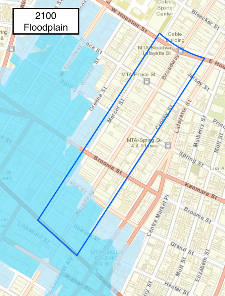
The maps above show the 100-year floodplain in darker blue and the 500 year floodplain in lighter blue. In the next 80 years, more of the District will be in the 100 year floodplain, meaning flooding may be more frequent. The approximate SoHo Broadway District boundaries are shown in navy blue.
Within the SoHo Broadway District, the southern blocks will face greater flood risk in the future. Currently, the blocks between Canal Street and Grand Street are within the estimated 500-year flood area. By 2100, the 500-year flood risk is projected to push north past Grand Street, and the blocks between Canal Street and Grand Street will be a part of the 100-year flood risk.
Heavy rains and aging infrastructure
Heavy rainfall can lead to flooding, even in areas far from any coastline or water body. Elevation, water table height, and the size and age of sewer infrastructure all contribute to flooding likelihood. The Department of Environmental Protection has developed a Stormwater Analysis Report in an effort to address the likely increased frequency and severity of flooding in the coming years. Some solutions include permeable pavement, rain gardens, and “blue belts” to improve water storage and absorption. In some cases, these improvements need to be accompanied by major infrastructure overhauls of pipes that are too narrow and too old.
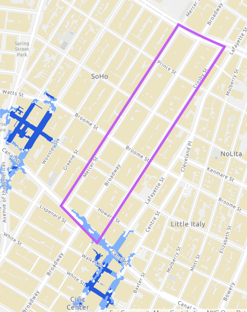
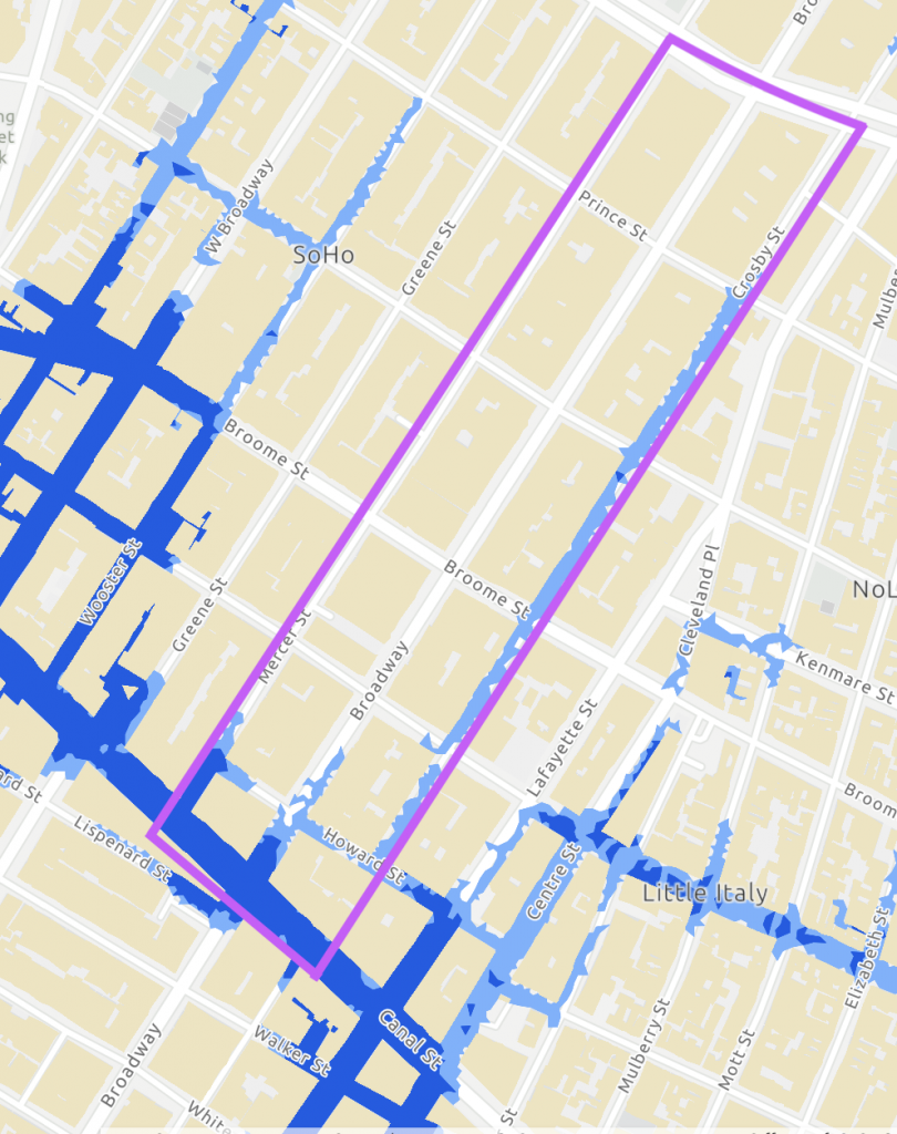
The maps above show where stormwater flooding could occur in the district after moderate-heavy rainfall at current sea levels (left) versus after extreme rainfall at 2080 sea levels (right). The approximated Initiative district boundaries are shown in purple.
The city has provided data showing how heavy rainfalls currently affect the SoHo area, and provided projections on how flooding may increase by the year 2080. In the map above, the intersection of Canal Street and Broadway emerges as the main spot for potential flooding in the SoHo Broadway Initiative district. In 2080, extreme stormwater flooding around West Broadway may spread east into the district, and flooding around Canal Street will spread north.
These new data and mapping platforms show how the past can inform our future. Locations in the district and in the broader SoHo area that have been identified as likely places of flood risk also have a historical record of flooding. Residents have noted stormwater overflows around West Broadway and Grand Street, and in the 2080 predictions show it as an epicenter of potential widespread flooding. Similarly, Canal Street has a long history of flooding. New data and projections paired with historic records of flooding can help prepare our community for future extreme weather, even as the City’s ongoing Lower Manhattan Coastal Resiliency and East Side Coastal Resiliency projects are being developed to reduce the risk of coastal flooding.
